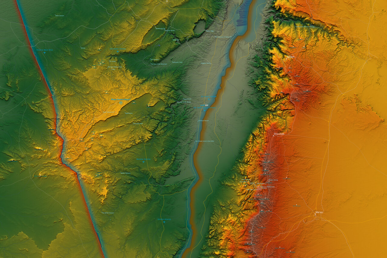
Atlas
Israel Atlas Map
1 : 500.000


Atlas
1 : 500.000
60 x 120 cm
Israeli Transverse Mercator
Atlas
International Boundaries, Capital Cities, Motorways and Major Roads, Primary and Secondary Roads, Airports, Seaports, Sea Routes, Archaeological Excavations, Colour Topographic Rendering, Rivers and Waters
Areas A and B according to the Oslo Accords, 1993 and 1995, between the State of Israel and the Palestinian Authority.
Area A is under full civilian and security control by the Palestinian Authority. Area B has extensive delegation of power to the Palestinian Authority with a joint Israeli-Palestinian security coordination. Area C, which is not marked because its outer borders became obsolete by the Oslo Accords has very limited delegations of powers to the Palestinian Authority and is under full Israeli security control.
2018
© 2018 Ronen Schmitz
© 2018 OpenStreetMap Contributors
| Cookie | Duration | Description |
|---|---|---|
| _pin_unauth | 1 year | This cookie is placed by Pinterest Tag when the user cannot be matched. It contains a unique UUID to group actions across pages. |
| _pinterest_ct_ua | 1 year | No description available. |
| yt-remote-connected-devices | never | YouTube sets this cookie to store the video preferences of the user using embedded YouTube video. |
| yt-remote-device-id | never | YouTube sets this cookie to store the video preferences of the user using embedded YouTube video. |
| Cookie | Duration | Description |
|---|---|---|
| _auth | 1 year | This cookie is set by Pinterest that collects statistical details to track the use of its services. |
| _ga | 2 years | The _ga cookie, installed by Google Analytics, calculates visitor, session and campaign data and also keeps track of site usage for the site's analytics report. The cookie stores information anonymously and assigns a randomly generated number to recognize unique visitors. |
| _ga_P62QC8P6L5 | 2 years | This cookie is installed by Google Analytics. |
| _gat_gtag_UA_165257691_1 | 1 minute | Set by Google to distinguish users. |
| _gid | 1 day | Installed by Google Analytics, _gid cookie stores information on how visitors use a website, while also creating an analytics report of the website's performance. Some of the data that are collected include the number of visitors, their source, and the pages they visit anonymously. |
| _pinterest_referrer | 5 minutes | This cookie is set by Pinterest to track the use of its services. |
| _pinterest_sess | 1 year | This cookie is set by Pinterest that collects statistical details to track the use of its services. |
| _routing_id | session | This cookie is set by Pinterest that collects statistical details to track the use of its services. |
| CONSENT | 2 years | YouTube sets this cookie via embedded youtube-videos and registers anonymous statistical data. |
| YSC | session | YSC cookie is set by Youtube and is used to track the views of embedded videos on Youtube pages. |
| Cookie | Duration | Description |
|---|---|---|
| _fbp | 3 months | This cookie is set by Facebook to display advertisements when either on Facebook or on a digital platform powered by Facebook advertising, after visiting the website. |
| fr | 3 months | Facebook sets this cookie to show relevant advertisements to users by tracking user behaviour across the web, on sites that have Facebook pixel or Facebook social plugin. |
| VISITOR_INFO1_LIVE | 5 months 27 days | A cookie set by YouTube to measure bandwidth that determines whether the user gets the new or old player interface. |
| yt.innertube::nextId | never | This cookie, set by YouTube, registers a unique ID to store data on what videos from YouTube the user has seen. |
| yt.innertube::requests | never | This cookie, set by YouTube, registers a unique ID to store data on what videos from YouTube the user has seen. |